Industry case studies
Industry use of space technology
Development of the space industry supports the growth of other economic sectors that are increasingly reliant on the use of space technology such as agribusiness, mining, maritime and defence. Just a few examples can be read below.
Space technology has a wide range of industry uses within the agricultural sector. The Precision Pastoral Management System (PPMS) is an instructive case example and has improved productivity and profitability for Northern Territory pastoral estates.
The PPMS remotely monitors the performance of cattle and pastures through NASA Landsat satellite technology, in combination with the walk-over-weighing system. The cattle, individually identified via an ear tag, walk over a weighing platform, and this data is recorded and uploaded via satellite to the pastoralist.
The NASA Landsat satellite technology also allows for remote sensing of pasture conditions by tracking changes in the growth, condition and grass diversity of the land. This information is then analysed and summarised through weekly reports, and includes information on live weight data of individual animals, and pasture condition and availability. The farmer can view this information at any time and from any location via a customised website.
This technology was developed in Alice Springs in the Northern Territory by scientists at the Cooperative Research Centre for Remote Economic Participation (CRC-REP), and trialled at five Australian beef cattle stations across north Australia. All told, it incorporates automatic weighing and drafting, automated communication processes, cloud-based analytics, satellite observation, and water management.
Benefits include: reduced labour and increased productivity, improved decision-making and responsiveness to environmental conditions, and long term sustainability through access to the data needed to adjust stock numbers and rest paddocks in response to conditions.

Space technology is a crucial component in bushfire monitoring. Its impact can be clearly seen through the North Australian Fire Information (NAFI) website. This tool was launched in 2004 and has been instrumental in managing and controlling the spread of fires in Northern Australia, encompassing Northern Western Australia, the Northern Territory and Northern Queensland1.
NAFI collates bushfire information such as hotspots (fire locations), recently burnt country (fire scars), and fire history. The fire scar mapping is sourced from the Darwin Centre for Bushfire Research at Charles Darwin University. This fire scar and hotspot information is based on NASA satellite images sourced from a combination of ground stations around Australia and processed by Landgate and Geoscience Australia.
NAFI contributes to the generation of significant economic benefits to northern Australia through better protection of infrastructure and property from fire, and via more effective and streamlined use of resources in fire control. It is also a crucial tool for Aboriginal land managers, ranger groups, and pastoralists in securing carbon credits via savanna burning projects. Early dry season burning has numerous environmental and safety benefits and the carbon credits earned from this activity are currently worth around $20 million a year, with significantly greater value generated in the form of indirect social and economic benefits2.
NAFI is constantly evolving, and is planning to incorporate satellite remote sensing for the level and intensity of fires through savanna regions, providing annual mapping of fire severity for fire managers.
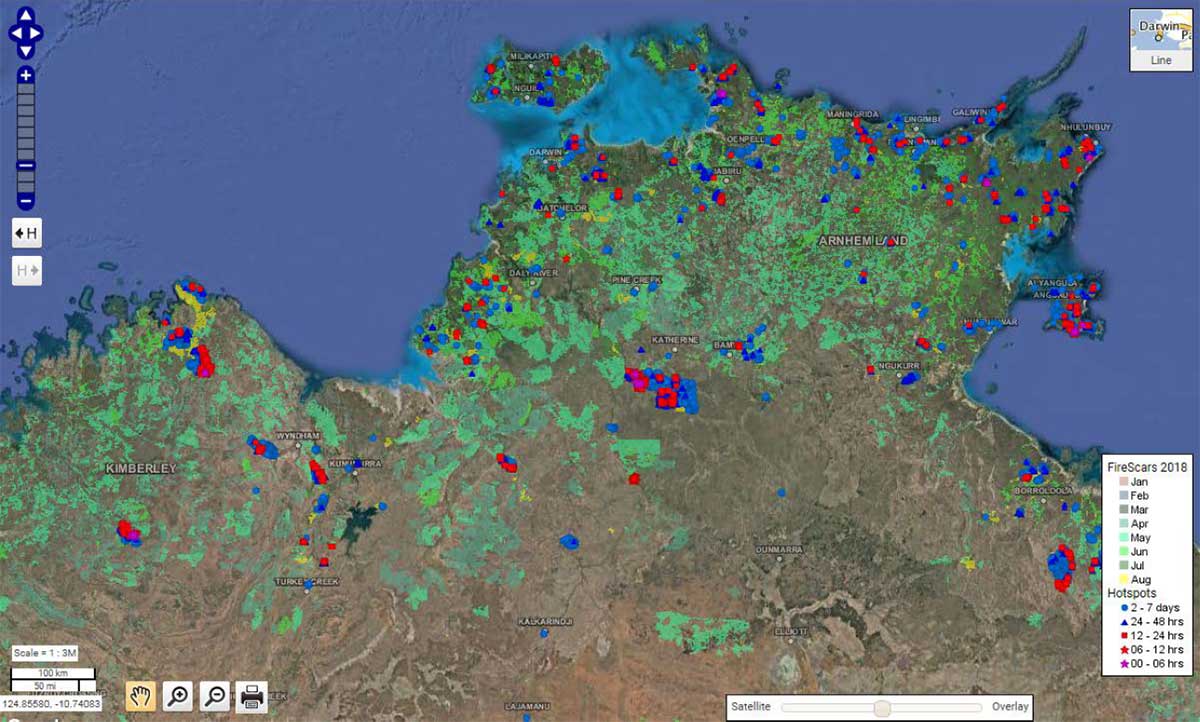
Figure 1: NAFI satellite image
1. https://firenorth.org.au/nafi3
2. Dr Peter Jacklyn, Darwin Centre for Bushfire Research - Charles Darwin University
Australia is using data from earth observation satellites for a range of operational, experimental and research land and ocean management applications. Calibration (adjustment and adaptation) and validation (verification and accuracy assessment) of these data using on- or near-ground information is essential to ensure sufficient levels of accuracy.
As most earth observation satellite operators are located in North America, Europe and Asia their calibration / validation efforts are focused on the northern hemisphere. In order to ensure satellite data on Australia's unique environment are accurate it is essential that Australia is collecting appropriate calibration / validation data and is feeding back this information to the satellite operators. At the same time this activity ensures Australia 'a place at the table' where these countries make decisions about future satellite systems.
The Savanna Supersite in Litchfield National Park has become a calibration / validation site for a number of international space programmes. In this scope the Northern Territory company maitec is collaborating with Geoscience Australia, CSIRO and a number of Australian universities, as well as with NASA, ESA (European Space Agency) and DLR (German Space Agency).
To collect calibration / validation data at the Savanna Supersite maitec has modified one of its unmanned aerial systems (commonly known as drones), originally developed with the support of the Northern Territory Government’s Department of Trade, Business and Asian Relations, for applications in horticulture, agriculture and aquaculture. The novel system allows the efficient collection of satellite calibration / validation data at tall vegetation and / or difficult to access sites.
Through this activity in the Northern Territory, Australia is making a unique contribution to the international satellite earth observation community1.
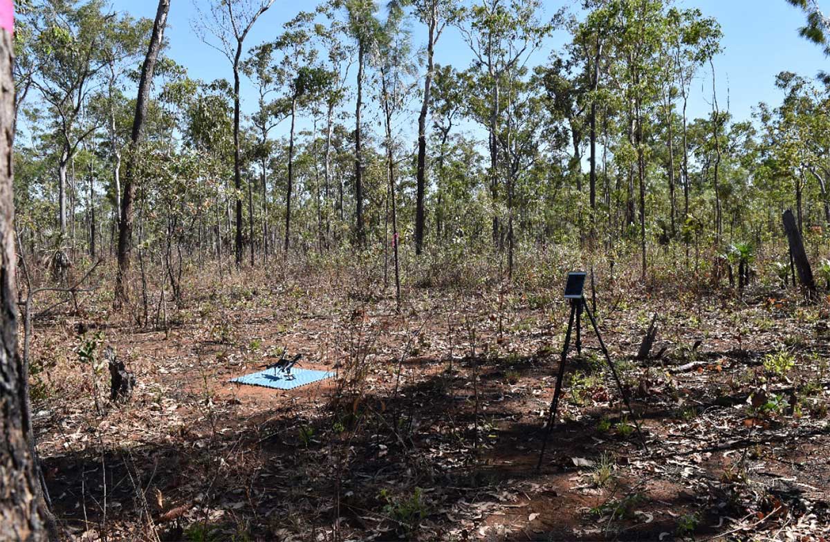
1. Case study provided by Dr Stefan Maier, maitec, www.maitec.com.au
In Australia, 300,000 to 900,000 square kilometres are affected by bushfires every year. Most of these fires occur in central and especially in northern Australia. These fires threaten infrastructure and people's lives and are a large source of greenhouse gas emissions. Due to the vast expanses and remoteness, earth observation using satellites is an essential source of information for efficient fire management.
Northern Territory company maitec has developed a range of novel fire information products utilising data from earth observation satellites, providing more frequent, timely and detailed information on bushfires.
maitec's fire extent mapping product is available to fire managers within two hours of the satellite overpass. Combining the information from multiple satellites allows the information to be updated multiple times per day.
Most countries use earth observation from satellite for inventory purposes long after the fire only. In contrast, this system allows Australian fire managers to be world leaders in utilising satellite-based earth observation for active fire management1.
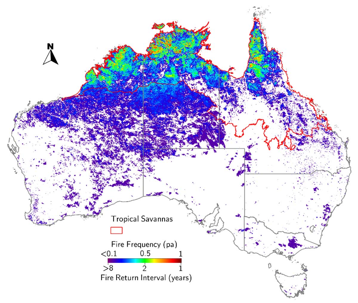
Figure 1: Fire frequency map derived from satellite earth observation
1. Case study provided by Dr, Stefan Maier, maitec, www.maitec.com.au
Space technology has a wide range of industry uses within the maritime sector, including the use of Vessel Monitoring Systems (VMS) in the Northern Territory’s (NT) barramundi industry.
The VMS is an electronic device fitted to commercial fishing vessels providing real time satellite tracking. The tracking is generally accurate to within 2 meters. The data collected by satellite is relayed to both the NT Police, and the fisheries division within the Department of Trade, Business and Asian Relations (DTBAR).
This data assists DTBAR to manage the long term sustainability of the industry, providing information on the frequency and location of fishing operations. The NT Police can also ensure that fishing vessels aren’t operating in prohibited areas.
VMS supports the provision of data used for monitoring compliance, fishing zone usage, adherence to area and seasonal closures, incident detection, and informing research and fisheries management.
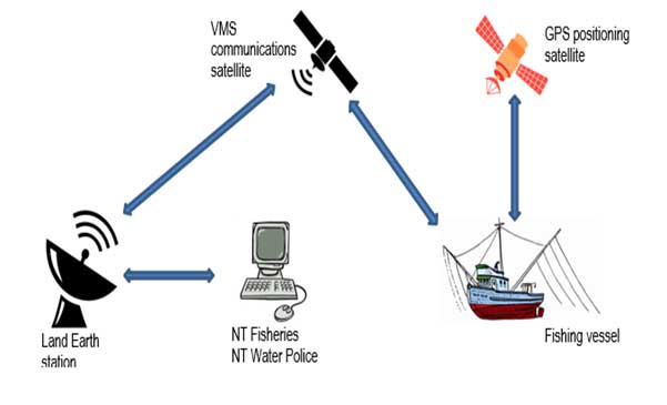
Figure 1: How the Vessel Monitoring System works
Space technology has a wide range of uses within the minerals sector, including enhancing the safety and efficiency of legacy mine site management across the Northern Territory. These mines have an estimated unfunded liability of over $1 billion. The Northern Territory Government’s legacy mines unit manages these sites through a geodatabase, remote monitoring, and the use of drone technology.
High rainfall during the Northern Territory’s wet season frequently makes it impossible to reach some mine sites. Historically this has made it difficult to manage some environmental risks, such as acid and metalliferous drainage. However, the installation of remote monitoring equipment (connected to satellite and broadband systems) at multiple legacy mine sites has made the process far easier. Officers can now remotely monitor site weather conditions, stream flows, water levels and water quality plus control systems remotely, such as activating solar powered bore pumps to collect contaminated groundwater (thereby preventing entry into waterways).
Many legacy mine sites are in remote locations. Accessing these sites can be timing consuming and dangerous for mining officers. Using space technology, a mining officer can now travel to a remote location, deploy a drone and cover many square kilometres in minutes, without having to leave the safety of their vehicle. Drone technology is also allowing for more efficient cataloguing of mine shafts, decision making through remote provision of high definition video of mine sites, and the ability to create 3D models to assist with rehabilitation.
The future looks even more exciting, with opportunities to take advantage of new low-orbit satellites, the increasing capability of drones, and more advanced software systems.
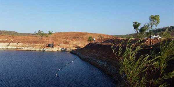
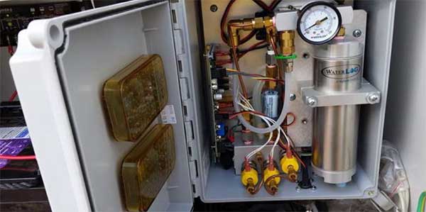
Figure 1: Floating EC sensor in Pit Lake
Space technology has a wide range of industry uses within the minerals sector. In 2012, the Northern Territory Geological Survey and CSIRO collaborated to produce 12 mineral maps to assist exploration companies identify prospective mineralisation production zones.
In a Territory first, the maps were drawn from satellite-acquired ASTER data. ASTER, which stands for Advanced Spaceborne Thermal Emission and Reflection Radiometer, is a Japanese instrument on the NASA satellite 'Terra' representing a US-Japanese cooperative effort in earth observation systems. The data drawn from this system is used to develop detailed maps analysing reflectance, land surface temperature and elevation. ASTER is also equipped with 14 spectral bands that can detect rock forming minerals from iron oxides to clays, carbonates, quartz, among others1.
When examining this data, Kentor Gold Limited (KCL), identified several unknown and unexplored copper-gold zones at the Jervois Copper-Silver-Gold project in the Northern Territory. Since KCL acquired the Jervois Copper Project, its exploration efforts have increased the estimated resource to 25.2 million tonnes containing 384,800 tonnes of copper and 23.6 million ounces of silver, together with gold, lead and zinc2.
Further advancement in the use of space technology will continue to assist companies in their exploration efforts.
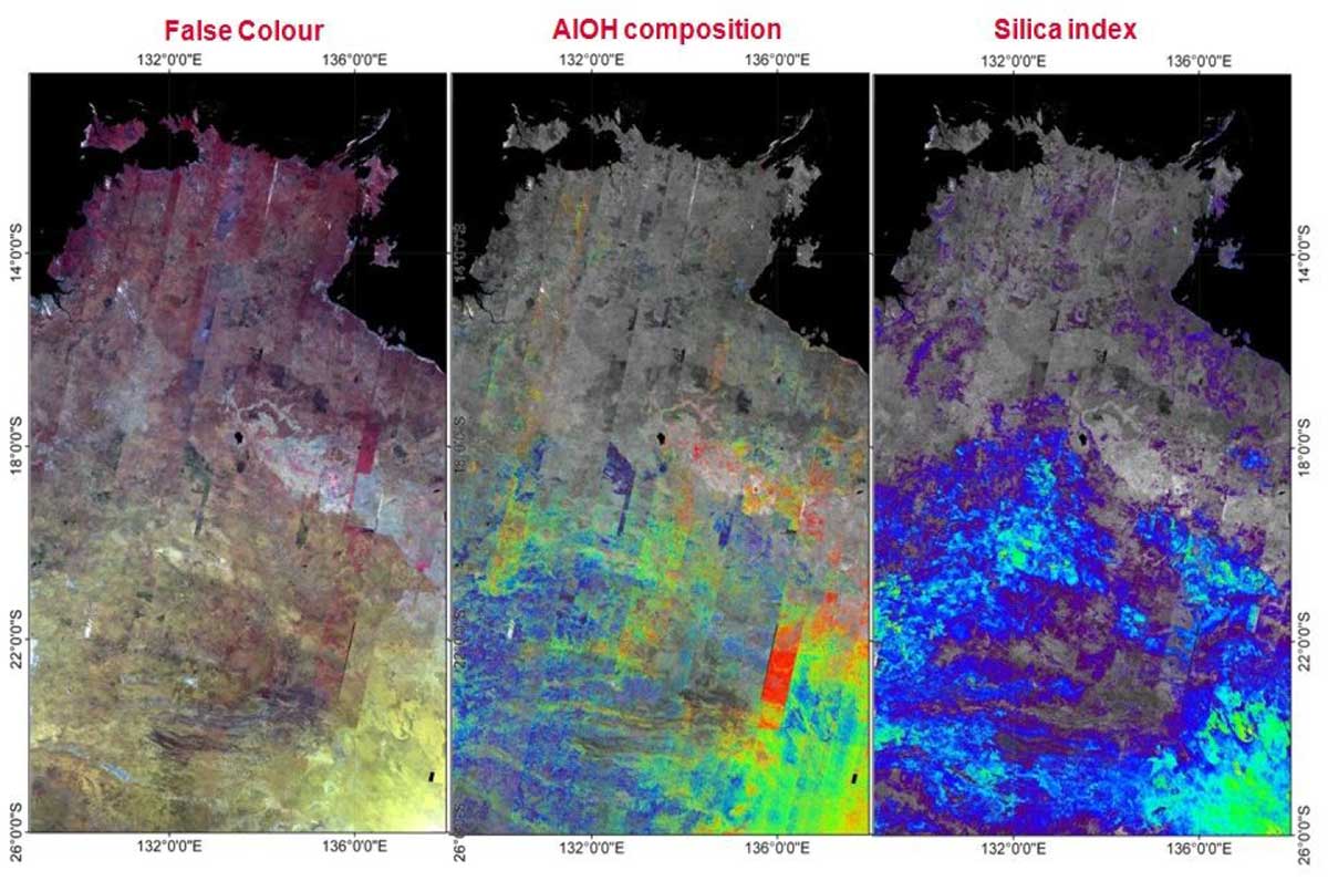
Figure 1: Satellite NT ASTER geoscience maps
1. Northern Territory ASTER Geoscience Maps
2. KGL Resources
Space technology has a variety of valuable applications in the minerals sector, but is particularly useful for enhancing mineral exploration. Core Lithium’s Finniss Project is adopting these technologies to accelerate its exploration activities and expand its lithium resource.
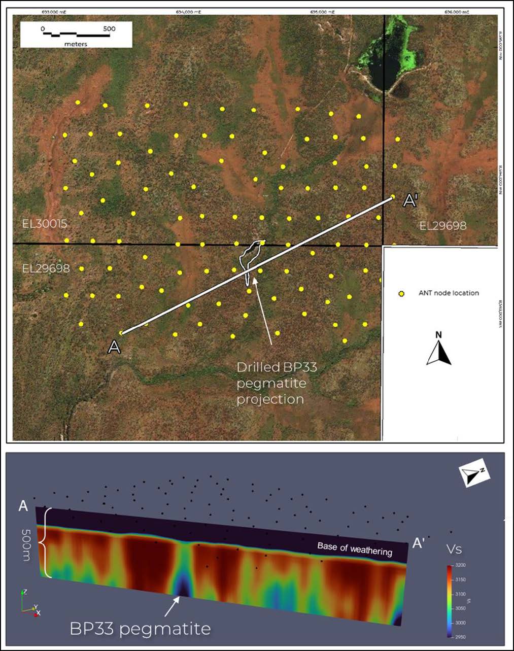
The Finniss Project is one of the first mines to embrace Fleet Space Technologies’ satellite-based mineral exploration system, ExoSphere. ExoSphere delivers 3D subsurface images much more rapidly than with conventional techniques, and takes days rather than months. The data is collected via Fleet’s seismic node technology – called Geodes – which have been designed specifically for ambient noise tomography (ANT). Geodes are far more sensitive than existing technology, providing important structural information on likely mineralisation at both regional and localised scales quickly, easily, affordably, and with minimal environmental impact.
The tool utilises satellite connectivity to a cloud platform, providing real-time remote access to survey results and processing data into a 3D visual representation. With zero time lost from manually harvesting, transporting, and interpreting data, decisions can be made rapidly, often while field teams are still on site. This allows for survey retargeting towards promising prospects, which reduces the time to achieve accurate value estimations of deposits.1
Core Lithium and Fleet Space Technologies initially partnered on a trial to test Exosphere’s effectiveness at detecting lithium pegmatites at depth (500m+). The trial produced outstanding results, spurring Core Lithium to sign a 12 month agreement with Fleet for delivery of Exosphere in August 2022. It’s Core’s intention to use the technology in untested areas to prioritise targets for drilling and significantly expand its lithium resource.2
For more information phone 08 8999 5369 or email investmentterritory@nt.gov.au.
Give feedback about this page.
Share this page:
URL copied!